Vancouver topographic map
You can find on this page the Vancouver topographic map to print and to download in PDF. The Vancouver elevation map present the topography, river and relief of Vancouver in British Columbia - Canada.
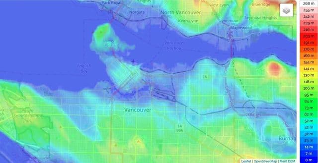
Vancouver elevation map
The Vancouver topographic map shows elevation, hills and landforms in Vancouver. This elevation map of Vancouver will allow you to know topography, river and relief of Vancouver in British Columbia - Canada. The Vancouver topographic map is downloadable in PDF, printable and free.
The physical features include Plateaus, valleys and plains, forests, as well as rugged mountains. The Western Cordillera was formed when the larger Pacific Plate converged with the smaller North American Plate. Since the North American Plate is smaller it went on top of the Pacific Plate. The smaller plate went up pushing the lager one into the mantle. As the plate went up in created mountains. That is how the western Cordillera was formed. The elevation of the mountains make it colder at the top of mountains or cities that are high in elevation. Relief rainfall is also a factor because of the jet stream blowing east and the mountain ranges as you can see in Vancouver elevation map. For this reason lots of cities get lots of rain all year round.