Vancouver metro map
You can find on this page the Vancouver metro map to print and to download in PDF. The Vancouver metro map presents the network, zones, stations and different lines of the metro of Vancouver in British Columbia - Canada.
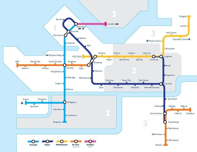
Metro map Vancouver
The Vancouver metro map shows all the stations and lines of the Vancouver metro. This metro map of Vancouver will allow you to easily plan your routes in the metro of Vancouver in British Columbia - Canada. The Vancouver metro map is downloadable in PDF, printable and free.
The Vancouver Metro, called SkyTrain, is an automated metro system, similar to the VAL system of Lille and Toulouse. Since August 2009, there have actually been two systems, incompatible with each other, the older Expo/Millennium Line and the newer Canada Line as you can see in Metro map Vancouver: Station platforms are 80 m long, which allows 6-car-trains; SkyTrain normally operates 4-car mark II trains, and 4 or 6-car mark I trains. The average station distance is 730 m in the city centre area and 1750 m in other areas. All stations now have elevators, after Granville was retrofitted with one in 2006. In the beginning trains got names like Spirit of Victoria, Spirit of Vancouver, etc. For the inauguration of the second line a new type of train (mark II) was ordered with cars 17.3 m long (earlier stock 12.3 m) and three doors per side each 1.6 m wide (compared with two 1.2 m wide doors per side on original cars).
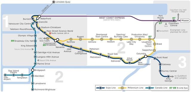
Vancouver subway map
The Vancouver subway map shows all the stations and lines of the Vancouver subway. This subway map of Vancouver will allow you to easily plan your routes in the subway of Vancouver en British Columbia - Canada. The Vancouver subway map is downloadable in PDF, printable and free.
Vancouver SkyTrain or Vancouver subway is a completely automated light rapid transit system, offering fast, efficient service between downtown and Metro Vancouver suburbs. There are three lines: The Expo Line runs south-east from downtown Vancouver, out to Burnaby, New Westminster and Surrey. There are four downtown stations as you can see in Vancouver subway map– Waterfront, Burrard, Granville and Stadium-Chinatown. Take one of these trains to visit Science World, get to Pacific Central Station, visit the Commercial Drive neighbourhood, or head out to Metrotown shopping mall in Burnaby or the River Market at New Westminster Quay. Trains run every two to five minutes.